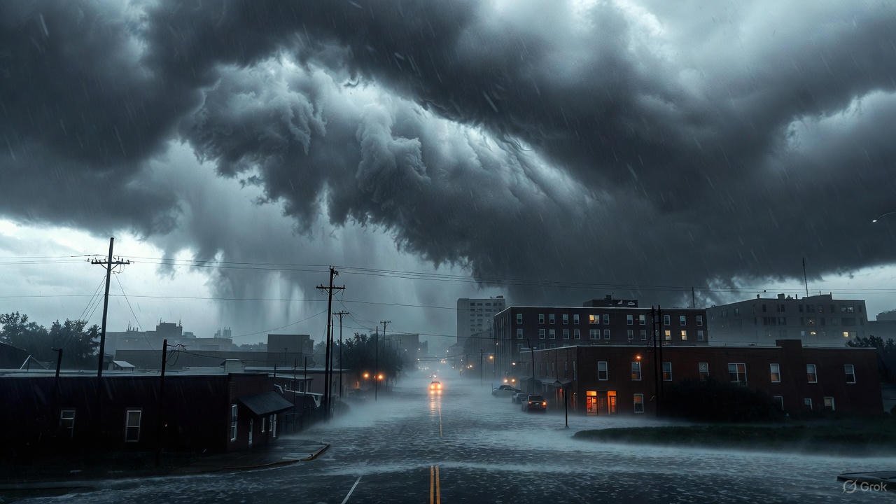
As the gray skies over Dallas thicken like a heavy blanket on this chilly November morning, residents north of Interstate 20 are on high alert. It’s Monday, November 24, 2025, and the National Weather Service has hoisted a Flood Watch across much of North Texas, warning of potential flash flooding that could turn familiar streets into rushing rivers. This isn’t just another rainy day in the Lone Star State—it’s the second such alert this week, coming hot on the heels of last Thursday’s deluge that left the soil spongy and streams swollen. For folks in Dallas, Fort Worth, and surrounding counties, the message is clear: stay vigilant, because Mother Nature isn’t done pouring yet.
The watch kicked off late Sunday evening around 6 p.m. and stretches through this afternoon until about 3 p.m., with some extensions possible into the evening if the rains linger. Areas along and north of I-20—from the bustling suburbs of Plano and Frisco to the rolling hills of Denton and Wise counties—are in the crosshairs. Meteorologists are eyeing rainfall totals of 1 to 3 inches across the region, but don’t be surprised if some unlucky spots rack up 4 inches or more in isolated bursts. That’s enough to overwhelm storm drains still recovering from the weekend’s soak and push creeks like the Trinity River tributaries toward their banks.
What makes this storm system particularly sneaky is its timing. North Texas has been hammered by a parade of Pacific moisture plumes over the past few days, turning what was once parched prairie into a saturated sponge. Last week’s rains dumped up to 5 inches in parts of the Dallas-Fort Worth metroplex, and the ground hasn’t had a chance to dry out. When you add today’s incoming front—a low-pressure system sliding eastward from the Plains—you get a recipe for rapid runoff. “The soil is primed for trouble,” says a report from the NWS Fort Worth office, noting that even moderate downpours could trigger flash floods in low-lying areas.
Local weather teams, including the pros at WFAA, are glued to their screens, providing real-time updates that have become lifelines for commuters and families alike. If you’re tuning in, the WFAA radar is your best friend right now—a dynamic swirl of greens and yellows painting a picture of the chaos unfolding. As of early this morning, the radar loop shows clusters of thunderstorms bubbling up from the southwest, marching steadily toward the metro area like an uninvited guest at a holiday dinner. Those brighter echoes? They’re packing rain rates of up to an inch per hour in spots, zeroing in on Collin and Denton counties where the watch is most intense. It’s mesmerizing and a little terrifying—watching the storm cells pulse and expand, their edges fraying like wet paper as they dump their load.
Take a peek at the WFAA radar yourself, and you’ll see why experts are urging caution. The interactive map highlights the flood-prone zones north of I-20, with animated arrows tracing the storm’s path: expect the heaviest bands to slide through between 7 a.m. and noon, easing off slightly by afternoon but not vanishing entirely. For drivers on I-35E or the Dallas North Tollway, that means hydroplaning risks on already slick roads. Schools in affected districts, like those in Lewisville and Allen, have issued early dismissal notices, while city officials in Dallas are pre-positioning sandbags at key underpasses.
But let’s zoom out a bit. This isn’t Dallas’s first rodeo with flooding woes. The city sits in a floodplain’s embrace, hemmed in by the Trinity River and its web of tributaries that swell dramatically during wet spells. Remember the Halloween floods of 2015? Torrential rains—up to 10 inches in hours—turned neighborhoods into lakes, stranding hundreds and causing millions in damage. Or the Mother’s Day deluge in 2015, when a stalled front unleashed biblical rains, prompting the evacuation of thousands along the Trinity. Those events etched a collective memory in the metroplex: water rises fast here, and it doesn’t mess around.
Fast-forward to today, and climate patterns are amplifying the drama. Warmer Gulf waters are fueling more intense moisture transport into the Plains, leading to what scientists call “rain bombs”—sudden, extreme downpours that overwhelm infrastructure designed for yesteryear’s weather. North Texas has seen a 20% uptick in heavy rain events over the last decade, per NOAA data, and urban sprawl isn’t helping. Impervious surfaces like parking lots and rooftops shunt water straight into streets, accelerating flood risks in places like Uptown Dallas or the Design District.
So, what does this mean on the ground? For starters, the economic ripple could be felt far beyond soggy shoes. Agriculture in Collin County, with its cotton fields and dairies, faces crop losses if fields turn to mud pits. Construction sites along the expanding DART lines might grind to a halt, delaying projects already behind schedule. And let’s not forget the power grid—Entergy Texas is bracing for outages, with tree limbs heavy from recent ice still vulnerable to gusty winds embedded in these storms. Winds could gust to 30 mph in squalls, toppling those weakened branches onto lines and leaving pockets of the city in the dark.
Health officials are chiming in too, warning of mold risks in flooded basements and the spread of waterborne illnesses if sewage overflows. The Dallas County Health Department has activated its emergency line, advising anyone wading through standing water to wear boots and report hazards promptly. For the vulnerable—elderly residents in mobile home parks north of I-20 or families in low-income apartments without basements—the stakes are higher. Evacuation routes are mapped out, but traffic snarls from rain-slicked highways could complicate escapes.
Safety isn’t just about dodging puddles; it’s about smart preparation. First rule: Never drive through flooded roads. That old adage—”turn around, don’t drown”—saves lives because just 12 inches of moving water can sweep away a car. Park in elevated garages if possible, and keep an eye on creek levels via apps linked to USGS gauges. Stock up on non-perishables, flashlights, and extra batteries—though with today’s forecast, it’s more about bridging a few soggy hours than hunkering down for days.
Local heroes are stepping up, as they always do. The Red Cross has opened a shelter at the Grapevine Community Center for anyone displaced, while volunteer groups like Dallas Area Habitat for Humanity are ready to tarp roofs and clear debris post-storm. And kudos to the first responders: Dallas Fire-Rescue’s swift-water teams are on standby, their boats and drones primed for rescues in flooded arroyos.
As the morning wears on, the WFAA radar tells a tale of two storms. The leading edge has already brushed southern Tarrant County, scattering showers that have slicked up sidewalks in Arlington. But the main show—a line of thunderstorms with embedded heavy rain—is barreling toward the core cities, its core glowing red on Doppler scans for rates exceeding 2 inches per hour. Meteorologist Ellen Bacca, anchoring WFAA’s coverage, breaks it down simply: “This system’s got a lot of juice left. We’re talking training echoes—storms piling up like cars in rush hour, dumping rain on the same spots over and over.”
By midday, the bull’s-eye shifts eastward, potentially sparing downtown Dallas the worst but hammering McKinney and Sherman harder. Farmers in Grayson County are eyeing their silos warily, knowing that prolonged wetness could rot stored grain. Meanwhile, event planners for this week’s Thanksgiving gatherings are scrambling—outdoor turkey trots in Frisco might pivot to indoor venues, and tailgates for the Cowboys’ Thursday night clash could be a washout if the pattern holds.
Looking ahead, relief isn’t immediate. The Flood Watch may lift by 3 p.m., but scattered showers linger through Tuesday, with another system brewing for midweek. Temperatures hover in the low 60s today—mild for late fall, but that warmth keeps the atmosphere juicy, reluctant to squeeze out the moisture. Highs tomorrow nudge into the 70s, but with 100% rain chances fading to 40% by Wednesday, there’s a glimmer of blue sky on the horizon.
In the broader scheme, this episode underscores a shifting normal for Dallas weather. What used to be a once-in-a-decade flood is inching toward annual unwelcome. City planners are pushing for greener infrastructure—rain gardens, permeable pavements—to soak up the excess. The Trinity River Vision project, with its levee upgrades and parkland buffers, aims to fortify against these assaults, but progress is slow amid budget battles.
For now, though, it’s about riding out the wave. Tune into WFAA for those radar refreshes every 10 minutes; their team is out in the field, from drone shots over White Rock Lake to live cams at Love Field, where flights are stacking up due to low ceilings. Social media buzzes with tips—@WFAAWeather’s feed is a goldmine of hyper-local alerts, from flooded intersections in Richardson to rising waters at Lake Lewisville.
As the lunch hour approaches, the first reports trickle in: a stretch of SH 121 near McKinney underwater, forcing detours; school buses navigating cautiously in The Colony. It’s a reminder that weather isn’t abstract—it’s the puddle your kid jumps in on the way to recess or the canceled soccer practice that bonds the family over board games.
Dallas has weathered worse and emerged stronger, its spirit as resilient as the oaks lining the Katy Trail. This Flood Watch is a chapter in that story, a call to community and caution. So grab that umbrella, check the basement sump pump, and keep the WFAA radar tab open. North Texas will get through this—wet socks and all—ready for sunnier days ahead.